The Importance of Science for the Observation of our Earth Environment by Satellites
ESSC Panel Chair Maurice Borgeaud outlines the history of mankind’s observation of our Earth by satellites, the commitment made by Europe for Earth observation, some of the most spectacular recent scientific breakthroughs, and the importance of continuing this scientific effort for understanding our Earth environment.
By MAURICE BORGEAUD
November 20, 2024
Earth observation (EO) satellites have been orbiting our skies since the beginning of the space era, just after Sputnik was launched in 1957. Although most of the initial missions were linked to defence and meteorological applications, the first Landsat satellite launched in 1972 by the USA, demonstrated it was possible to use this technology for civilian applications such as agriculture, and land mapping.
If the demonstration of existing technology that could be flown in space was one of the drivers to build new EO satellites, the link between science “pull” (or demand) and technology “push” was then further nurtured. As a result, nowadays, most of EO science satellites must fulfil scientific requirements and not only demonstrate new technology. Moreover, in the development of new satellites, compromises are often made by relaxing strict scientific requirements to avoid lengthy and costly technology developments. This highlights the fact that, even in space exploration, the pursuit of new scientific discoveries goes hand-in-hand with the creation of cutting-edge technologies.
Many nations and agencies have developed their own EO satellites. At the beginning NASA successfully pioneered the observation of the Earth with the Landsat series; currently Landsat-8 and Landsat-9 are operating. However Europe is currently in a leading position worldwide in this field with the prominent roles taken by European Space Agency (ESA) and the European Commission (EC). This is very likely due because Europe is currently investing almost as much as NASA in EO [1] although the overall NASA budget is more than threefold when all space activities are included.
It is worth noting the numerous and flourishing national activities of the ESA member states such as: the SPOT, SWOT programme in France, TerraSAR/TanDEM-X, EnMAP, and GRACE in Germany, COSMO-Skymed, PRISMA in Italy, PROBA in Belgium, etc. These missions are all successes in their own right, and showcased the great leaps Europe has taken in recent years in the EO field. Other countries such as Japan, Canada, India, China, Korea, and Russia are also very active in using data collected by EO satellites to monitor the Earth. A good illustration of the cooperation in this field has been demonstrated since 2000 with the creation of the “International Charter Space and Major Disasters” [2] for which 17 members worldwide are contributing with more than 270 EO satellites when a natural disaster strikes the Earth.
The work performed by the European Space Agency (ESA), together with its member states, should be particularly commended since the development of ERS-1 and ERS-2 in the 1980’s (culminating in their launches respectively in 1991 and 1995), followed by the launch of ENVISAT in 2002 which operated 5 more years than its planned lifetime until 2012.
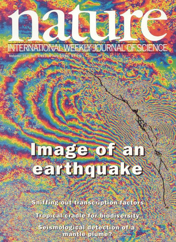
A striking example of a groundbreaking science discovery allowed by EO satellites is the “image” of an earthquake using the concept of spaceborne synthetic aperture radar (SAR) interferometry, first developed at NASA-JPL, but only fully demonstrated and exploited with the tandem use of ERS-1 and ERS-2 (i.e. ERS-2 passing the same point on the ground one day later than ERS-1) as shown in the figure below.

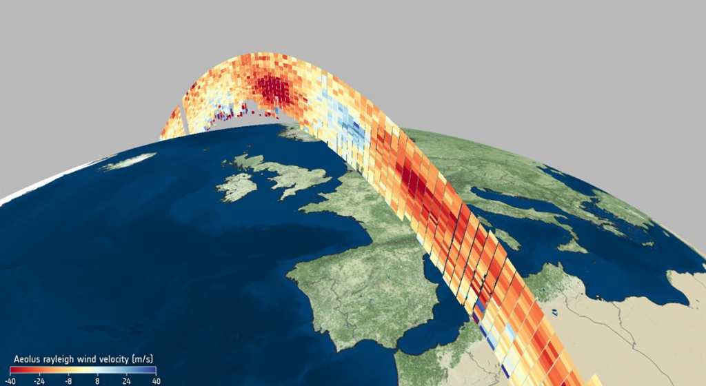
In the mid-1990s, ESA established the Living Planet Programme with focused missions defined, developed, and operated in close cooperation with the scientific community. This programme led to the series of very successful Earth Explorer missions [3]. The first one was GOCE in 2009, followed by SMOS, CryoSat-2, SWARM, Aeolus, and finally EarthCARE which was just launched in May 2024 but has already shown some remarkable results on how clouds and aerosols influence the heating and cooling of the atmosphere [4]. Several additional Earth Explorers are currently being built and all these missions continue to demonstrate how the latest technology can deliver an astounding range of scientific findings about our planet. One of the selection criteria for any new Earth Explorer includes how scientific advances anticipated from the mission contribute to addressing major societal issues (e.g. food security, water scarcity, climate change). The case of the Aeolus Earth Explorer is prominent as it allowed for the first time in 2018 to fly in space an active doppler wind lidar allowing measurements of global wind profiles from the surface to 20 km altitude as shown in the figure below.

The impact of AEOLUS on numerical weather forecasting has been so significant that it is regarded as one of the most critical satellite missions for improving forecast accuracy.
The ESA Living Planet Programme also recommended to develop more service/applications-driven EO missions which formed the basis of the Global Monitoring for the Environment and Security (GMES), which became later Copernicus, led by the European Commission. ESA has been entrusted with the development of the space component of Copernicus and is responsible for the development of the Sentinel missions. Copernicus is considered as one of the best systems of satellites to monitor the Earth and its environment. It is currently made of 8 satellites [5]carrying state-of-the art remote sensing instruments, together with 30+ contributing missions [6]. Even more important than the satellites themselves are: (i) the free, full, and open data policy associated with Copernicus, and (ii) the continuity of data guaranteed well beyond 2035 through the Sentinel C and D series, along with the Sentinel Expansion missions [7], the first of which—focused on monitoring anthropogenic dioxide carbon emissions—is set to launch by 2026.
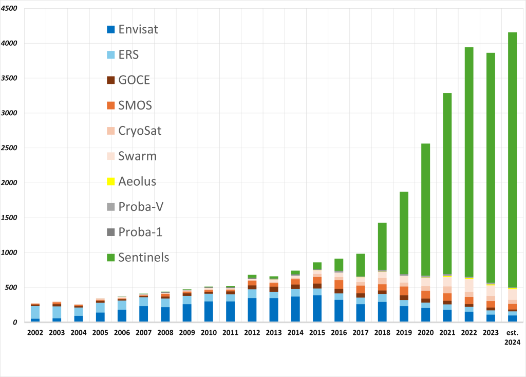
Science and technology have been the driving forces behind the remarkable development of Earth Observation (EO) satellites for over 50 years. While Copernicus was not specifically designed to meet scientific objectives, but rather to support EU sectoral policies (e.g., fisheries, climate, agriculture), its success is built on the advancements made by the ERS and ENVISAT satellites, including the use of their data to foster new applications. Notably, the growing number of peer-reviewed publications using ESA EO satellite data underscores the increasing importance of Copernicus/Sentinel data in scientific research.

With the Earth Explorers, Copernicus, and EO national missions, Europe has demonstrated it can lead worldwide the field of Earth observation by satellites. In order to achieve it, pushing the frontiers of science and using innovative technologies have been of paramount importance for the development of new EO satellites. Let us not forget it when important decisions are about to be taken for the future of this domain in Europe.
References
[1] ESA 2024 budget dedicated for EO was 2.37 B€ while NASA Earth Science Division budget request for the fiscal year 2024 was 2.47 B$, https://www.nasa.gov/wp-content/uploads/2023/03/nasa-fy-2024-cj-v3.pdf
[2] https://disasterscharter.org
[3] https://www.esa.int/Applications/Observing_the_Earth/FutureEO/Earth_Explorers_ESA_s_pioneering_science_missions_for_Earth
[5] Sentinel 1A, 1B, 2A, 2B, 3A, 3B, 5B, 6-Michael Freilich. To be noted that Sentinel 1B is no longer working but should be replaced by Sentinel 1C before the end of 2024 and Sentinel 2C was successfully launched in September 2024, but is still in commissioning phase
[6] https://www.copernicus.eu/en
[7]https://www.esa.int/Applications/Observing_the_Earth/Copernicus/Copernicus_Sentinel_Expansion_missions

